It’s been a while, but I haven’t forgotten about my blog, I have just been super busy and/or slack 🙂 Since I last posted, I have become PADI dive instructor and have spent most of this year in Indonesia diving in Bali, Komodo and Raja Ampat. This post is about that journey…
I have been diving since 1992 – yes you read that right, that’s 23 years – and kept the flame alive with annual diving trips to exotic locations all over the world, including Australia (naturally), Fiji, Papua New Guinea, Solomon Islands, Samoa, Cook Islands, Belize, Red Sea, Maldives and Indonesia. But it wasn’t until I first dived Komodo (off the western coast of Flores, eastern Indonesia) that I was inspired to turn the passion into a profession.
My first trip to Komodo was in April-May 2013 and by August that year I was back to take my Divemaster (the first rung of the professional diving ladder). In February 2014 I moved to Honiara to work as a volunteer, but after 10 months there I was back to Indonesia to dive some more and to take my PADI instructor development course (IDC). Man that was hard work; here are some photos of the IDC, instructor exam and Master SCUBA Diver Trainer course that followed (photos courtesy Crystal Divers and Felicia Lindgren).
The motley crew
Pool skills – lift bag
Rescue skills in the pool – our favourite part of the Instructor Development Course!
All tied up
Yes, we did practise our knot-tying a LOT
Knot tying is FUN!
Theory…
Open water skills
Practising CESA…
Nervous before my first pool demo in the Instructor Exam
Pool skills PASSED!
After our open water demos in the Instructor Exam
Post-theory exam in the Instructor Exam
I passed!
Deep dive
Navigation!
Search and recovery – knot tying!
Setting up the drop tank
Search and recovery – swimming increasing circles
Wreck diving at Tulamben
Perfect hover 😉
Finally some fun diving at Nusa Lembongan 🙂
So that’s my dive instructor journey in a nutshell… I will put up a post of my Raja Ampat and Komodo adventures very soon.
OK, OK, dear readers I know I’ve been really bad this time. I am overdue on writing this blog post by ummm 5 months… In my defence, I have been sooooo busy since I did the trip that is the subject of this post – what with wrapping up my life in Solo, attending the World Parks Congress in Sydney, a whirlwind trip to Canberra and unpacking/reorganising/repacking to move to another country (in a record 5 days), then moving to said country with all that it entails… phew! Then in January I took the course to become a SCUBA diving instructor (only 1 month or so of my life) and in February squeezed in a trip to see family overseas. Do I have your forgiveness now? I do hope so 🙂
So, moving right along, this post follows on from my previous one (Awareness Part 1), in which your faithful correspondent – along with Ministry colleagues – took part in a program to raise awareness about protected areas in Isabel and Choiseul provinces as well as Wagina and the Arnavon Islands, Solomon Islands. The second phase of our awareness program involved communities in Marovo Lagoon, Roviana Lagoon, Tetepare Island and Western Province (New Georgia and Ghizo). My itinerary went something like this: Seghe-Chea-Tetepare-Munda-Kolombangara-Munda-Gizo-Sepo Island-Saeraghi-Honiara. If you can’t remember where all these places are, you can refer to this map from an earlier post, and below is a more detailed map of the Marovo Lagoon area.
Map of Marovo Lagoon, Solomon Islands, showing New Georgia and Tetepare Island, courtesy http://www.siartc.org.sb
Awareness program
Over about a two week period we met with communities, community leaders, individual families, conservation organisations, rangers and scientists. At each proposed site we did a preliminary visual assessment, including on snorkel, to get an idea of conservation value. It was really useful to see first-hand what various communities wanted to protect and hear about the reasons behind it, as well as to compare sites.
It was also a rare opportunity for communities and individuals to talk face-to-face to Ministry staff about other issues and concerns they are facing (unregulated logging, pollution and poaching amongst them) and to find out what they can do about it. It was clear that many communities and traditional owners don’t know what their legal rights are and despite the great work of the Landholder Advocacy Legal Support Unit of the Solomon Islands Public Solicitor’s Office (LALSU), there are many communities falling through the gaps and LALSU doesn’t have the capacity to address these.
Here is the photographic record of our journey…
Aerial photo over Marovo Lagoon, one of the largest lagoonal systems in the world
Welcome sign, Berina Guesthouse, Seghe, New Georgia
Dockside, Berina Guesthouse
The view from the Berina Guesthouse jetty looking across to Vangunu Island
Delicious home-cooked dinner of fish and vegies from the ladies at Berina Guesthouse
The courthouse at Seghe
Coconut crabs for sale at the local market, Seghe
Chea Village from Kahaini Island
Meeting with the Tetepare rangers to talk about the new legislation and hear from them about enforcement issues
Munda on a calm morning is hard to beat, with views to Kolombangara (the sleeping woman)
Readying our steed to depart fair Tetepare. There were a few more of us than this (11 actually) and it was not the least stressful boat ride I’ve ever taken! (Photo courtesy MECDM)
On our way to Munda, New Georgia, Western Province (photo courtesy MECDM)
The sandy roads of Munda
The jetty at Nusa Tuva, the place to be!
The view from the Nusa Tuva guesthouse across the water to Kolombangara
The guesthouse at Nusa Tuva in traditional leaf hut style
The beautiful kids of Nusa Tuva, Kolombangara, always have a smile for you
My colleagues Debra and Agnetha checking the reef at Nusa Tuva
Smiles all around – ia man!
My colleage Rose, snorkelling for the first time… dugong totem nao 🙂
Agnetha on snorkel
Debra on snorkel
Canoes, Kolombangara
Moonset over Gizo
Playing it cool in Saeraghi, Ghizo (Solomon Islands). Photo: MECDM
Evening awareness program with the Saeraghi community, Ghizo, Western Province (photo courtesy MECDM)
Sunset at Saeraghi, Ghizo, Western Province
A big thanks to Salome Topo and the staff at Worldwide Fund for Nature‘s Gizo office, who kindly helped us out with our meetings on Ghizo (the island, not the town).
A note on a few off-the-beaten-path gems…
I was so excited to get the opportunity to travel to Tetepare Island on this trip, and it truly is a spectacular sight. In the end we only had a heart-breakingly brief day and a half there, but it was enough to leave me salivating for more… Tetepare is the largest unlogged island in the Pacific, and it has a wonderful bunch of passionate rangers, community leaders and biologists working hard to keep it that way. We were lucky to meet the rangers and caretakers, as well as John and Katherine Read, who have played a huge part in driving the conservation of the island until now.
On Tetepare Island, me and my Ministry colleagues with Tetepare rangers and seagrass girls (photo courtesy MECDM)
Educational posters in English and Pidgin, Tetepare Island (photo courtesy MECDM)
This reef is regularly surveyed, along with other areas, to feed into the Tetepare Island Management Plan (photo courtesy MECDM)
If you’d like to learn more about Tetepare, and/or how you can visit, their website is very informative. You can read about the fight to save Tetepare in John and Katherine’s book, “The Last Wild Island: Saving Tetepare“.
Another group of communities working hard to conserve and manage their resources sustainably is those on Kolombangara Island, through the Kolombangara Island Biodiversity Conservation Association (KIBCA). You can support their work by visiting the Imbu Rano Lodge, which we visited as guests of KIBCA. Sadly our schedule didn’t allow us to stay overnight but it is a great place to get back to nature and hike the high mountains of Solomon Islands.
Imbu Rano Lodge, Kolombangara
The view from the verandah at the Imbu Rano Lodge to the high peaks of Kolombangara is spectactular (untouched virgin forests), even in the mist
Diving
Thankfully it wasn’t all work and I managed to fit in a few dives as well 😉 While hanging around Seghe I met Lisa Choquette for the first time and checked out Solomon Dive Adventures‘ new operation near Chea (Marovo Lagoon). Later, while loitering in Munda, I squeezed in a few cheeky dives with Jen and Graeme at Dive Munda. Diving in both places was outstanding and my hosts could not have been more accommodating, fun and knowledgeable. Both are highly recommended!
Marovo Lagoon
The indomitable Lisa Choquette, at Kahaini
Lisa is mad keen about fish (and as a fishy person that made me very happy!) and she happily took me for a snorkel around the tiny island of Kahaini where SDA is now based to show off what it has to offer.
All I can say is WOW. I don’t remember ever seeing such diversity in such a small area. There are six different habitat types and such an astounding number of different varieties of organisms that I thought my head was going to start spinning – I didn’t know where to look next… and don’t get me started on the dive sites!
Suffice it to say that if you are the sort of person who doesn’t like 5-star resorts and wants to identify all the critters you’ve seen after every dive, you need to meet Lisa. For the record, my first dive with her started like this:
And my last dive ended with this:
Munda
Sharks, amazing healthy coral gardens, walls, sharks, rays, bumphead parrotfish, tuna, Napolean (Maori) wrasse, nudibranchs, barracuda and did I mention the sharks? Destination diving at its best – really. I was very impressed by my dives at Munda. If anyone is interested in which sites I dived I will dig out my logbook but it definitely included Shark Point and Cave of the Kastom Shark. Let my video speak for itself. Sadly the hammerhead I saw on my first dive was too shy so I didn’t get him/her on video, but here are the rest of the best bits.
It was a huge trip and I was pretty exhausted after all those hours in tiny tinnies and all the heavy Solomon Islands food, but I feel very privileged to have been able to see parts of the Sollies that others don’t have access to. That and my amazing counterpart Agnetha, and the rest of my team at MECDM, without whom my time in country wouldn’t have been what it was.
Mi tangiu tumas fo evrisamting an mi barava missim iufala evriwan brata an sista blo mi lo Solo xx
And ending with a gratuitous money shot – from a fabulously relaxing afternoon of snorkelling, crayfish and soothing music at Fatboys Resort, a short boat ride from Gizo.
Always a tough way to spend an afternoon – Fatboys Resort and Restaurant, near Gizo
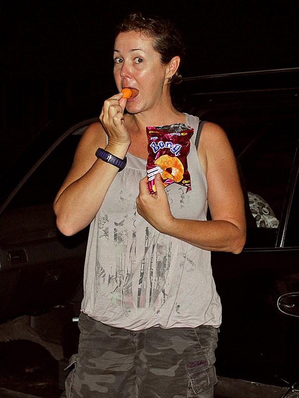
The running joke in our office – we are all totally addicted to Bongos (for the Aussies, they are as close as you can get to Cheezels in Solo) (photo courtesy MECDM)
After an extremely busy past couple of months I have finally had time to post about my adventures travelling through the Solomons with my workmates from the Ministry of Environment, Climate Change, Disaster Management and Meteorology, conducting awareness about the protected areas work we have been doing. I have split this into two posts, one for Isabel-Arnavons-Wagina-Choiseul and one for Western Province. Picture-heavy content coming up…
In September and October, I – along with various colleagues – travelled to the provinces of Isabel, Choiseul (including the Arnavon Islands and Wagina) and Western Province. Our primary purpose was to talk with local communities, non-government organisations (and partners) and provincial governments about how they can protect and sustainably manage their land, sea and resources, as well as to hear from them about some of the issues they are facing.
Many small boat trips, several plane rides and multiple compressed vertebrae later, here is the story in pictures. Enjoy!
Leaving Honiara on – well, not exactly a jet plane
The lovely white sand beach at Fera, Isabel Province, makes for a nice airport stop
Hanging out with my colleagues at Fera airport, Isabel Province
Buala sea view, Isabel Province
View of Buala, Isabel Province, from a nearby island
After a very hot day in Buala, Isabel Province, we hiked up to this waterfall to cool off
Mangrove seedlings are being grown here for replanting – a project by The Nature Conservancy, Buala, Isabel Province
The first of many awareness presentations given by my colleagues, Kmaga, Isabel Province
Kids surfing in their kanus, Kmaga, Isabel Province
The first of many long boat rides… leaving Buala for Baolo, Isabel Province
Snack time, Baolo, Isabel Province
Suavanao air strip, Isabel Province
Early evening arrival to Engatubo, Isabel Province
Engatubo village is built out over the water opposite Kia Community, Isabel Province
Awareness presentation, Engatubo, Isabel Province
Kia, Isabel Province
Waiting for the rain to stop, Kia, Isabel Province
Welcome sign, Arnavon Islands
Guest house, Arnavon Islands
The view from the ranger station, Arnavon Islands
Moray eels hide in the mangroves to hunt small fishes, Arnavon Islands
Walking the beach path with Moses, one of the fantastic Arnavon Islands rangers
Rangers mark each turtle nest with the expected hatch dates and cover it with wire to protect it from predators
Hawksbill turtle hatchling, Arnavon Islands
One of the turtle rookeries in the Arnavon Islands is on this beautiful beach. Both green and hawksbill turtles nest here.
Green turtle hatchling, Arnavon Islands
Off to snorkel the Arnavon Island protected area
Sandy cay, Arnavon Islands
Soon-to-be-dinner fishes, Arnavon Islands
Megapod eggs, Arnavon Islands
Our dinner, Arnavon Islands
Turquoise blue waters and swaying palm trees – the Arnavons are tough to leave
Our boat ride from Arnavons to Wagina had many amazing views
If you want to experience the excitement of baby green turtles hatching, this is your lucky day – because I videoed it 😉
To learn more about the Arnavon Islands, check out the Arnavon Islands website and TNC’s website. There are links on the latter if you’d like to make a donation to support TNC’s conservation work.
Before you ask, yes I have been associating with far too many of our brothers and sisters across the Tasman. Bat, hem fitim…
I was recently lucky enough to join staff from The Nature Conservancy on a field visit to Choiseul Province, in the north-western Solomon Islands. Choiseul – unpopulated, densely forested, ringed by beautiful white sand, remote – you probably never knew it existed. Funny name for a Pacific Island too and just where the heck is it again? Well, it turns out that the French had explorers too, and patriotic ones at that (the local name for Choiseul is Lauru). As for where it is, put it this way – you can see Bougainville from the provincial capital, Taro…
Visiting Choiseul is, in a lot of ways, like stepping back in time. It’s the real Solomon Islands – the place I came to explore. After a few months in Honiara, one can sometimes forget that it is nothing like the rest of the country…
The view from the Lauru Land Conference of Tribal Communities/TNC office ain’t half bad
Our visit to Choiseul took us to three villages – Zinoa, Nukiki and Poroporo. The aim of the trip was for TNC to finalise some protected areas applications and to help communities assess the stocks of trochus inside two locally-managed marine areas (LMMAs).
Choiseul map, courtesy Google Maps
Our trip started at dawn, with a flight from Honiara to Taro stopping over at Gizo. We then travelled by ray boat to the various villages, the furthest around 1.5 hours from Taro.
Dawn flight from Honiara
It was a smaaaaall plane 🙂
The Gizo stopover has a lovely view of Kolobanggara Island (the sleeping woman)
The air strip at Taro
Our low-key arrival into Taro
Nali nuts for sale at the Taro market
Fresh fish for sale, Taro
Heading to Zinoa Village
For the first three days, Seno from TNC and I visited the villages of Zinoa, Nukiki and Poroporo to talk about protected areas. Over the second three days I joined other TNC staff and local communities on trochus surveys. We had a really warm welcome at every village we went to; our lovely hosts at Nukiki even boiled some water for my shower! Our accommodations were very comfortable – at Zinoa we stayed in the guest house on a separate island, in Nukiki we stayed with one of the local ladies, and at Poroporo we were settled in at nearby Perama Lodge.
Getting dinner ready, Zinoa
Cooking hut, Zinoa
Beautifl big trees shade the beach at Zinoa
Canoe on the beach at Zinoa
Nukiki village
Our bedroom, Nukiki village
View of Perama Lodge
Perama Lodge
Zinoa village has protected a large area of sea around two small islands, one of which is completely uninhabited and for which you must seek permission to visit. It is virtually impenetrable and is home to coconut crabs, among other wildlife. The other of the two islands is the site of the comfortable guest house.
The LMMA at Zinoa
Exploring the Zinoa LMMA
Nukiki village’s LMMA (Redman) is at Paspasbarego Island close to Taro, and has a small house on site. We had a good tour of the island and I later snorkelled the surrounding waters as part of the trochus stock assessment surveys inside and outside the LMMA.
Paspasbarego Island near Taro, Choiseul
Our final destination was Poroporo and Perama LMMA, which comprises the waters around Perama Island. The LMMA at Perama is really nice, and has wonderful snorkelling. Nearby there is some great spearfishing to be done – and just to ensure the trip wasn’t too unexciting we managed to get caught in a lightning storm (forked, not sheet – one hit the beach right in front of us – eek!).
Perama LMMA has a beautiful healthy reef
Gorgeous neon blue Chromis take refuge in staghorn coral, Perama LMMA
Batfish, Perama LMMA
Anemone fish, Perama LMMA
Trochus survey, Perama LMMA
Measuring trochus, Perama LMMA
Nearby Poroporo village is well known for delicious mud crabs, and I was lucky enough to score a few as a gift from the community.
Poroporo mud crabs – before
Poroporo crabs – after
They were delicious.
Speaking of food, we were fortunate to have the fabulous Mary Kereseka cooking for us, along with the ladies from the Lauru Land Conference of Tribal Communities (LLCTC). We were treated to amazing local food, including fresh squid, crayfish and fish. We were even included in Mary’s daughter Alice’s birthday celebration feast. Very special.
Fresh crayfish – what a treat
Chef Mikie Gins cooking squid
Squid in its own ink
Alice’s birthday lunch feast
Choiseul string bags
While in Choiseul I was very keen to track down a few kastom string bags (or “kuza“), after hearing a lot about them from my friends and colleagues in Honiara. Luckily I found some! These bags are in demand from Solomon Island ladies because they are light and strong and can hold a lot. They are also completely organic!
Choiseul kastom string bag, or “kuza”
A lot of work goes into these bags, as I discovered after speaking with a few of the ladies who make them… They are made from the bark of the tulip tree, sheets of which are soaked in seawater and then dried in the sun. Once dry, the bark is separated into fibres, which are rolled on the thigh to make twine. It is this process that takes all the time – a simple market bag (diagonal mesh) can take up to one month to make, and a more detailed “bubuzai” type bag (square mesh, reinforced) can take 3-4 months.
Generally the women charge around $50 for a basic market bag and $100-200 for a more complicated design or a larger bag. It may seem a lot, but next time you think about haggling, remember how long they have taken to make!
All in all, it was a fantastic experience visiting Choiseul and the communities there. I would strongly recommend it to anyone who would like to go further off the beaten track in the Solomon Islands, you won’t be disappointed 🙂
I recently visited Indonesia to dive in Komodo Marine Park, off the island of Flores, for the third time. It seems I can’t stay away – the SCUBA diving there is some of the best I have ever done and I keep going back for more 🙂
I spent two weeks there, and did around 10 days of diving with the company I did my Divemaster with last year. We had a brilliant time, with some fantastic dives and lovely guests on the boat. I found my first daytime mandarin fish, guided a bunch of dives, ate a lot of rice and caught up with friends. While I was working most of the time I did manage to take some photos to share with you.
So without further ado, welcome to Komodo…
The Naring crew, dive instructor Juvens and me
The dive deck on Naring
A turtle heading for the surface to take a breath
Tatawa Besar is one of the most beautiful dive sites in northern Komodo
School of bat fish at Tatawa Besar
Fishes everywhere at Tatawa Besar
Manta cleaning station at Manta Point (Makassar Reef)
Manta ray, Manta Point
Maori (Napoleon) wrasse at Batu Bolong
Fish soup on Batu Bolong
There be dragons! The entrance to the national park on Rinca Island
The view of northern Komodo national park (Komodo Is in the distance) from the top deck of Naring
Inside the marine park
Chicken, with other stuff – night market, Labuanbajo
The ubiquitous sunset shot (from Paradise Bar, Labuanbajo)
I’ll be back to Komodo as soon as I can, and feel free to ask me for tips and recommendations. Trust me, it’s worth the trip for the diving alone, but if you need added incentive there is a great Italian restaurant with authentic wood-fired pizzas 🙂
It’s been some time since my last post – apologies for that, I am still alive and kicking! Life has been going on as usual and I have been busy at work. I have managed to find time for a bit more diving though, so I think it is time I reported on some of the sites to be dived around Honiara. Mostly that is where I have been diving, though I squeezed in a short trip to Komodo (Indonesia) and one to the Russells with Bilikiki in the past month as well. Maybe I need to do a few diving posts 🙂 Apologies also for the lack of underwater photos – I plan to update this post with photos as I take more.
So, to the topic at hand – diving in and around Honiara (aka “H-town”). The diving, almost without exception, is wreck diving. There are a LOT of wrecks in the waters off Guadalcanal, thanks to a little WWII skirmish known as the Battle of Guadalcanal. In a nutshell, the Allied Forces launched a surprise attack on Japanese forces occupying the Solomon Islands and within six months or so it all went to custard for the Empire of Japan. This was a pivotal strategic victory that led to Japan’s surrender and the end of WWII. History buffs can read more about the campaign here and here.
Early morning dives are the best! This is at Bonegi I (B1)
The wrecks themselves? Well I have only done a handful of the many, many wrecks in Ironbottom Sound (why do you think it’s called that?). You can get an idea of the numbers by looking at this map (though it is not entirely accurate). For context, below is a map of the Solomon Islands.
It is a tech diver’s (and, let’s face it – bloke’s) paradise here, with many of the wrecks sitting in more than 50m of water, some intact and able to be penetrated, and some still with cargo (e.g. motorcycles, tanks, jeeps) on board. The key accessible ones close to Honiara are the ones I have included here. For anyone looking for more historical detail on the commonly-dived wrecks, this is a great resource.
Bonegi I/B1 Hirokawu Maru
A Japanese transport ship that was attacked by American dive-bombers and sank in November 1942
(depth 3–57m, location 12.5km west of Honiara, measured from the yacht club)
The beach at B1
This is the most-dived wreck near Honiara, probably because openwater divers as well as experienced and tech divers can all discover its charms. I’ve been shallow and deep on this wreck, and have done some limited penetration at around 46m toward the stern. I’m no authority on wrecks and don’t know all the cool terminology to use, but it was interesting to go inside. There were some big grouper and sweetlips hanging out in there, and soft corals and sponges growing on the inside, but I still prefer diving the top 15m because of the fish and coral life on that part of the wreck.
There are many lionfish to be found on B1 (Courtesy R. Duckworth)
You can always find nudibranchs, many species of anemone fish on and around the wreck in shallower waters (I once counted 14 different species), and there are often big schools of snappers, drummers, fusiliers and trevally hanging out around the masts. I’ve also seen octopus, crown-of-thorns starfish, crayfish and juvenile lionfishes.
Look carefully and you can find all kinds of cool stuff, like this nudibranch, on B1 (Courtesy R. Duckworth)
Bonegi II/B2 Kinugawa Maru
A Japanese transport ship that sank with Bonegi I
(depth 0–28m, location 12km west of Honiara right next to B1)
B2 from the Bonegi beach – it is the only one to break the surface (Courtesy R. Duckworth)
I have dived this very little because of consistently bad visibility. It has suffered over the years from earthquakes and other various things that have caused parts of it to collapse. It is now leaking oil as well, so I fear it won’t last much longer in its current condition. But, when you can see enough to dive it, it is worth doing.
The wreck at B2, shortly after the April floods (Courtesy R. Duckworth)
Orange anemone fish at B2 (Courtesy R. Duckworth)
The wreck is resting on sand and starts very shallow water (as you can see from the above photo, the top of it is actually out of the water) and goes down to around 28m. There are a few swim-throughs in the shallow parts and heaps of soft and hard coral growth all over the hull.
Bonegi III/B3 Kyusyu Maru, Azumasan Maru and Sasako Maru
A trio of Japanese cargo ships, locally known as Ruaniu, beached and bombed side by side in October 1942
(depth 7–47m, 39–80m and 58–85m respectively; location 17km west of Honiara)
The Beach at Bonegi III (B3)
The vessels have settled just off the beach, in close proximity to each other. I have dived the shallower two of these wrecks, which are frequently plagued by poor visibility (including because of lots of plankton). However, both can be penetrated and both have very nice underwater life. Because of the plankton there are a lot of feeding fishes, feather stars and soft corals.
Diving the shallower of the three transport ships at B3, Ruaniu (Courtesy R. Duckworth)
There are some beautiful fan corals on B3 (Courtesy R. Duckworth)
B-17 Flying Fortress
Lying on a sandy bottom close to shore, this American B17E Bomber was shot down in September 1942
(depth 14–17m, location 24.5km west of Honiara)
The gun turret of the B-17, encrusted with growth but still easily recognisable
The wreck is generally intact, with only its tail missing (thanks to a botched salvage operation) and a broken wing. Until recently you could even sit in the cockpit, though apparently someone did so a little too vigorously and broke it. It’s still a very cool wreck to dive though; it’s a super easy shallow muck dive, you can see the whole plane at all times, and there are heaps of little critters all over the place. It’s actually my favourite of all the local dives I’ve done here – I’ve seen sweetlips and snappers, nudibranchs, pipefishes, clouds of glassfishes here, and stingrays in the sand.
Five-lined snapper school around the turret and gun barrel
One of the B-17’s engines, with propeller
The B-17’s cockpit, still mostly intact
It seems obvious to say, but these wrecks are changing all the time in response to their environment. Just in the past 6 months the B-17 has been further covered in silt. For an idea of how it used to look, see this blog with photos taken in 1992.
Submarine I-1
A J1 type Japanese submarine, beached and sunk in January 1943 west of Visale Beach
(depth 3–28m, location 40km west of Honiara at Veura)
The sub is out there!
She lies at a 90-degree angle to the reef with her stern on the sand at 28m and is a good 20-minute swim from the beach, so save your air and take your snorkel if you intend to dive her. This wreck has an interesting history, which explains why there are big hunks of metal all over the reef adjacent to the wreck.
The “front” of the submarine
Apparently some fool of an Australian tried to blow her up 40 years ago to get access to valuable metals, not realising there were still live torpedoes inside. The resulting carnage is what you see today, and it also fired a table-sized piece of shrapnel into the local village. That being said, it is a very nice dive. The remainder of the sub is recognisable and you can penetrate a good part of it. There are several large air tanks (not torpedoes!) inside and a lot of life in, on and around it. The nearby reef is really nice and healthy. Last time I dived it we had loads of fish schooling around, and I saw several tiger cowries and anemone fishes. I’ve also seen bumphead parrot fish here and large snappers and sweetlips hiding in and under the wreck. Others have seen manta rays here and there are a lot of nudibranchs in the nearby reef, so try not to rush back once you’ve dived the wreck.
The submarine hull – the front part has been blown apart but the back is mostly intact
Most of the submarine can be penetrated
No, they’re not torpedoes, just air tanks! (I-1 Submarine)
I also found some crazy clown fishes on my way back from the sub…
After all this diving, you’ll probably be ravenous. Luckily you can grab some KFC on your way back to Honiara (that would be “Kakambona Fried Chicken”). They also do fish and local freshwater prawns, served with cassava and rice on a banana leaf-lined palm leaf plate. Mmmmmm.
The delicious Kakambona Fried Chicken (KFC)
Getting into the KFC post-dive at Kakambona Beach
The view isn’t bad either, just don’t look too closely at the dogs.
Kakambona Beach
And that’s all from me for now folks… stay tuned for more diving adventures – next stop, Komodo!
Lxx
The village at Veura is well organised for diving and the locals are friendly
The beach at Veura, looking toward Savo Island
Veura locals gleaning the local reef
The ribs of the I-1 submarine
Batfish and other large fishes are often found sheltering under the wreck (I-1 submarine)
Penetration! (The back part of the I-1 submarine)
A school of fusiliers whizzing past the submarine
The top of the submarine supports a tropical garden
There are loads of nudibranchs on the reef adjacent to the submarine, as well as on the wreck itself
The impact of the April flooding is still easily visible around the China Town area in Honiara. The old China Town bridge, which was washed away in the disaster, has left quite a hole in the Honiara landscape. As well as being a beautiful old bridge, it served the community with the flow of pedestrian traffic in addition to the cars.
As often in Solomon Islands, where there is a problem, there is generally also an entrepreneurial person, using their initiative to create a (temporary) solution. This is certainly the case across the Mataniko River. Where the bridge used to be, ropes have been tied to each side. Boats, or large polystyrene blocks, are being used to ferry the passengers across the water, with someone pulling the vehicle along using the rope. The ‘drivers’ are wearing gloves to ensure their hands are not damaged during each trip. Large poles are also…
It’s now been three weeks since the devastating floods in Honiara and life is starting to get back to some semblance of normality. There is plenty of work still to be done, and assistance still needed, but things are slowly improving.
As I mentioned in my last post I have not been involved much in the recovery efforts. The extent of my involvement has been getting out in a banana boat before Easter with ministry colleagues to assess the extent of erosion, sedimentation and debris caused by the heavy rains across northern Guadalcanal.
Travelling by banana boat to assess the damage caused by Cyclone Ita
I was surprised to find that the damage was not all that bad, particularly in the west. I was expecting much more debris after the tidal surges and rains, but it was relatively limited.
Erosion has caused land slips and trees to be uprooted, north-western Guadalcanal
Some areas have a lot of timber debris following the storms, north-western Guadalcanal
Close to town there were much greater impacts – a lot of logs, trees and other timber debris in front of the Heritage Hotel and Kokonut Cafe; a huge plume of dirty water from the Mataniko River and more serious erosion east of the river mouth at Renandi.
The sea at the mouth of the Mataniko River is still pretty dirty
I know many of my fellow volunteers are working extremely hard, and are doing some great work here with the clean-up efforts, but for me it is back to business as usual. To that end, and to lighten the mood a bit from my previous post, I am going to focus the rest of this update on my Easter dive trip to the Russell Islands and Mary Island (aka gloating).
Bilikiki trip report
Thanks to my mate Cath, I had booked my berth within weeks of arriving in country and it was really lovely to get out of town and be spoiled for a change. We vollies don’t often get to experience the finer things the Solomons has to offer, so I enjoyed every minute and it was worth every penny.
Sunrise in the Russell Islands
The MV Bilikiki (named after a local sea bird) is a dive boat out of Honiara that offers luxury 7-14 day live-aboard trips exploring the Floridas, Russells, Mary Island and Marovo Lagoon. They also offer occasional highly sought-after weekend trips to Honiara locals. For our Easter long weekend we left Honiara on Good Friday evening and returned on the evening of Easter Monday, and were offered five dives a day for the first two days and three dives on the final day. The Bilikiki comes with all the trimmings – hot freshwater showers on the dive deck, air-conditioned rooms with comfy beds and blankies as well as en suite bathrooms with hot water showers, great food, fantastic staff and the diving isn’t bad either.
Our diving schedule for the day
Our first day was spent in the Russell Islands diving at Kovilok Bay, Leru Cut, Custom Cave and Mirror Pond during the day as well as a night dive (which I didn’t do). I took the opportunity to experiment with my new(ish) underwater camera and strobe – bought last year for my trip to Komodo and only used twice before – so I finally have some photos to share. I forgot my red filter though, so the wide angle shots are a bit blue…
Pink anemone fish hiding in its host anemone, Russell Islands
The highlight of Day 1 for me was Leru Cut, a volcanic passage with a sandy bottom terminating in a cavern. My strobe wasn’t much use in the dark, so my photos aren’t great but you get the idea.
Diving the Leru Cut, Russell Islands
Outside the cut was a different story – a new species of anemone fish (check out the bonnet) and some beautiful gorgonian fans, complete with pygmy sea horse. Wonderful healthy reef with staka fish as well.
Bonnet anemone fish, Russell Islands
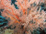
Gorgonian fan with feather star, Russell Islands
After a great day of diving (and in between dives as well), the crew fed us fabulous food – starting with sunset canapés on the upper deck and ending with divine chocolate tart. I don’t even like chocolate, but I forced it down to be polite. There’s nothing worse than a sobbing chef, so I sacrificed myself for the greater good. I would have taken a photo of it, but it didn’t last long enough. Sorry.
Sunset canapés on the top deck of the Bilikiki
After dinner we weighed anchor and steamed to Mborokua (Mary) Island , an uninhabited (and virtually inaccessible) volcanic island covered in jungle located just west of the Russells.
The wild and beautiful Mborokua (Mary) Island
On Day 2 we dived Barracuda Point, Jackfish Point, Mary Bommies and back to Barracuda Point, with a night dive just under the boat (again, not done by me!). This was my first experience of diving in close proximity to an active volcano. I was super excited to be back in the water – so at first I thought I was having heart palpitations – but it turned out to just be a bit of seismic activity. There were some pretty loud rumbles and strong vibrations! As well as the excitement of the volcano, the reefs at Mary Island are packed full of spectacularly healthy hard corals.
Mary Island has fantastically healthy hard coral gardens
I’m told there are usually a lot more pelagics than we saw, but perhaps they were on holiday. The best I could do was some trevally and barracuda.
School of barracuda at the aptly named Barracuda Point, Mary Island
That night we headed back east and woke up in the Russells again. Our last three dives were at Rainbow Reef, Fonagho Island and Lolaghan Island, and I was in love. Rainbow Reef was spectacular. Komodo-esque even. It is a sea mount, just like Castle Rock in the Komodo National Park, and was our first dive of the day so still a bit dark, but wow – it was pumping. Beautiful healthy reef, a bit of wall (I love a wall), heaps of fish feeding in the current and staka small stuff as well.
Fishes and plankton aplenty at Rainbow Reef, Russell Islands
Even the safety stop was interesting – we saw (and felt, not so much fun) some big plankton near the surface, along with a school of teeny tiny cuttlefish. Totally awesome.
Baby cuttlefish at the surface, Russell Islands. Cute huh?
But it wasn’t all about the diving. In between dives we didn’t just stuff our faces, we also met some of the locals.
Local villagers tie up in their canoes to sell us fresh fruit and veges, Russell Islands
And enjoyed the view from the upper deck.
Above the water the Russell Islands are equally attractive
Sunset over Guadalcanal
We also stuffed our faces 😉
Thanks for reading!
Lxx
Bilikiki Cruises is supporting Red Cross Relief & Recovery efforts in the Solomon Islands. For every donation over AUD50 you can go into the draw to win a 7 night live-aboard dive trip.
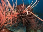
Soft coral with feather star, Russell Islands
Soft coral, Russell Islands
So many beautiful soft corals, so little time – Russell Islands
Pink anemone fishes inside host anemone, Russell Islands
Clouds of fishes hover over a Pocillopora coral head, ready to dart in amongst the branches at the first sign of danger, Russell Islands
Backlit school of barracuda, Russell Islands
This nudibranch was easy to spot, Russell Islands
Now you see me… Longnose hawkfish on a gorgonian fan, Russell Islands
Now you don’t… Longnose hawkfish hiding in a gorgonian fan, Russell Islands
Diving at the amazing Rainbow Reef, Russell Islands
Where are you from and when did you arrive?
Originally from Brisbane, but I lived in Canberra for nearly 10 years. I arrived in February 2014!
What brings you to Solomon Islands? I’m here to work as an AVID volunteer with the Ministry of Environment, Climate Change, Disaster Management and Meteorology. I’m a Protected Areas Adviser there, helping the Ministry to declare protected areas in the Solomon Islands.
What’s your favourite thing to do here? Dive!
What’s the most amazing thing you’ve done in your life? Hmmm that is a tough one, I am constantly trying to top the last amazing thing… I can’t narrow it down to just one but my highlights so far include doing my Divemaster in Komodo, Indonesia, channelling Indiana Jones in the western desert of Egypt, diving with sailfish, dolphins and mantas in the Maldives and getting vertigo at the Priekestollen on the Sognefjord in…
By now many of you will be aware that we had a tropical low sitting just south-west of Guadalcanal for much of last week (the prelude to Cyclone Ita), resulting in heavy rains and flash flooding. I have been told that it’s hard for others to get an idea from the limited media reports on the crisis though, so let me share with you some of my experiences over the past week.
It started raining on Tuesday 1 April and kept raining. It rained, and rained, and rained. It rained non-stop in Honiara for five days and the resultant flooding has been reported as one of the worst natural disasters in the country’s history. I grew up in south-east Queensland and am used to tropical downpours and wet seasons. I also went through the 2011 Brisbane floods. But I have never experienced rain like the rain we had in Honiara last week.
The heavens opened and the water just thundered down.
The Mataniko River in flood, Honiara 4 April 2014 (Courtesy K. Crombie)
The force of the water has widened drains, washed away river banks and has scoured out channels creating valleys and canyons. It has washed huge amounts of sediment down from the hills, covering roads and filling up drains, which then overflowed onto roads – making them impassable.
Further up the Mataniko River you can see the rivers of mud left behind after floodwaters receded, Honiara 4 April 2014 (Courtesy A. Bransby)
And as if that wasn’t enough, there were extraordinary high tides on Wednesday 2 and Thursday 3 April and an earthquake that hit Makira Province on Saturday night (5 April). We felt the tremors in Honiara – my housemate came running down from her room asking if I just felt the earth shake…
Earthquakes and general dampness aside I was extremely lucky, however many local residents did not fare so well. Houses along the Mataniko River were swept away in raging floodwaters, which wrought a wide path of destruction through Chinatown to the ocean, taking with them the Chinatown bridge and washing away the abutments of the Mataniko Bridge. People were caught up in the torrent and carried out with the debris, some later rescued by fishing boats.
The Mataniko River in full flood – taken from the Mataniko Bridge, Honiara 4 April 2014 (Courtesy A. Bransby)
The flooded mouth of the Mataniko River, Honiara 4 April 2014 (Courtesy A. Bransby)
A girl with an umbrella sits at the end of the road, where the Chinatown bridge used to be, Honiara 4 April 2014 (Courtesy A. Bransby)
Mananiko River after the floodwaters had receded, Honiara 5 April 2014
Mid-Mataniko River valley from Skyline Drive – there used to be houses here, Honiara 5 April 2014
The site of the Chinatown Bridge on Mataniko River, Honiara 5 April 2014
The latest news on the ground is that around 50,000 Solomon Islanders have been affected by the disaster, mostly on Guadalcanal. The official death toll is presently at 23 but there are many missing and the death toll is expected to rise. More than 9,400 people are homeless and sheltering in evacuation centres with limited supplies and inadequate sanitation, increasing the risk of disease outbreak. Emergency relief has started to arrive now that the airport has reopened, but more help is needed.
A New Zealand air force plane bringing emergency supplies lands at Honiara airport, 7 April 2014 (Courtesy M. Nunan)
I and many of the other volunteers and expats in-country have tried to help in whatever way we can, including helping out at evacuation centres, loading trucks with food supplies and donating food and sanitary products. Many of us have experienced frustration that we haven’t been able to do more, or in some cases anything useful at all. I have been struggling with feelings of guilt (that I really wasn’t affected in any material way) and powerlessness that I cannot channel my compassion for these amazing people into action. First world problems I suppose, but the urge to help is fierce. Maybe one thing I can do is to help raise awareness of the situation here.
Water levels got pretty high – some locals saw the upside, Honiara 4 April 2014 (Courtesy A. Bransby)
Huge amounts of debris were swept downstream in the flood and ended up on the banks of the Mataniko River (Courtesy A. Bransby)
The overwhelming sense I have from this experience is that the Solomon Islands people are incredibly resilient and brave in the face of exceptionally difficult – and heart-wrenching – circumstances. That being said, they still need help to rebuild their lives. Emergency supplies, including pharmacy and medical supplies, are urgently needed.
If you would like to help, please consider a donation to